
William B. Bankhead National Forest topographic map
Interactive map
Click on the map to display elevation.
About this map
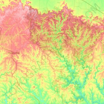
Name: William B. Bankhead National Forest topographic map, elevation, terrain.
Average elevation: 761 ft
Minimum elevation: 476 ft
Maximum elevation: 1,132 ft
Other topographic maps
Click on a map to view its topography, its elevation and its terrain.
Lewis Smith Lake
United States > Alabama > Winston County
Lewis Smith Lake, Winston County, Alabama, United States
Average elevation: 682 ft
Haleyville
United States > Alabama > Winston County
Haleyville, Winston County, Alabama, 35565, United States
Average elevation: 856 ft
Wilson Bend
United States > Alabama > Winston County > Wilson Bend
Wilson Bend, Winston County, Alabama, United States
Average elevation: 574 ft
Arley
United States > Alabama > Winston County
Arley, Winston County, Alabama, United States
Average elevation: 686 ft
Double Springs
United States > Alabama > Winston County
Double Springs, Winston County, Alabama, 35553, United States
Average elevation: 741 ft
Natural Bridge
United States > Alabama > Winston County
Natural Bridge, Winston County, Alabama, 35577, United States
Average elevation: 719 ft