
East Falkland topographic map
Interactive map
Click on the map to display elevation.
About this map
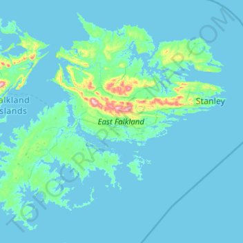
Name: East Falkland topographic map, elevation, terrain.
Location: East Falkland, FIQQ 1ZZ, Falkland Islands (-52.35909 -59.73648 -51.23353 -57.71210)
Average elevation: 79 ft
Minimum elevation: -3 ft
Maximum elevation: 2,277 ft
Other topographic maps
Click on a map to view its topography, its elevation and its terrain.
West Falkland
West Falkland, Islas Malvinas, Falkland Islands
Average elevation: 105 ft
Port Howard
Falkland Islands > Port Howard > Port Howard
Port Howard, Islas Malvinas, Falkland Islands
Average elevation: 148 ft