
Lake Ontario topographic map
Interactive map
Click on the map to display elevation.
About this map
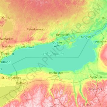
Name: Lake Ontario topographic map, elevation, terrain.
Location: Lake Ontario, Ontario, Canada (43.15936 -79.92529 44.29337 -76.04535)
Average elevation: 702 ft
Minimum elevation: 230 ft
Maximum elevation: 2,293 ft
Lake Ontario is the easternmost of the Great Lakes and the smallest in surface area (7,340 sq mi, 18,960 km2), although it exceeds Lake Erie in volume (393 cu mi, 1,639 km3). It is the 13th largest lake in the world. When its islands are included, the lake's shoreline is 712 miles (1,146 km) long. As the last lake in the Great Lakes' hydrologic chain, Lake Ontario has the lowest mean surface elevation of the lakes at 243 feet (74 m) above sea level; 326 feet (99 m) lower than its neighbor upstream. Its maximum length is 193 statute miles (311 kilometres; 168 nautical miles), and its maximum width is 53 statute miles (85 km; 46 nmi). The lake's average depth is 47 fathoms 1 foot (283 ft; 86 m), with a maximum depth of 133 fathoms 4 feet (802 ft; 244 m). The lake's primary source is the Niagara River, draining Lake Erie, with the Saint Lawrence River serving as the outlet. The drainage basin covers 24,720 square miles (64,030 km2). As with all the Great Lakes, water levels change both within the year (owing to seasonal changes in water input) and among years (owing to longer-term trends in precipitation). These water level fluctuations are an integral part of lake ecology and produce and maintain extensive wetlands. The lake also has an important freshwater fishery, although it has been negatively affected by factors including overfishing, water pollution and invasive species.
Other topographic maps
Click on a map to view its topography, its elevation and its terrain.
York
Canada > Ontario > Haldimand County
York, Haldimand County, Ontario, Canada
Average elevation: 646 ft
Nobleton
Canada > Ontario > York Region > King
Nobleton, King, York Region, Golden Horseshoe, Ontario, L0G 1N0, Canada
Average elevation: 866 ft
Waterford
Canada > Ontario > Norfolk County > Waterford
Waterford, Norfolk County, Ontario, N0E 1Y0, Canada
Average elevation: 791 ft
The Blue Mountains
Canada > Ontario > Grey County
The Blue Mountains, Grey County, Ontario, N0H 2P0, Canada
Average elevation: 869 ft
Sauble Beach
Canada > Ontario > Bruce County
Sauble Beach, South Bruce Peninsula, Bruce County, Ontario, N0H 2G0, Canada
Average elevation: 617 ft
Domville
Canada > Ontario > Leeds and Grenville Counties > Augusta
Domville, Augusta, Leeds and Grenville Counties, Eastern Ontario, Ontario, K0E 1X0, Canada
Average elevation: 338 ft
Negeek Lake
Canada > Ontario > Renfrew County > Madawaska Valley > Combermere
Negeek Lake, Combermere, Madawaska Valley, Renfrew County, Eastern Ontario, Ontario, Canada
Average elevation: 1,004 ft
Loveland Lake
Canada > Ontario > Kenora District > Unorganized Kenora District
Loveland Lake, Unorganized Kenora District, Kenora District, Northwestern Ontario, Ontario, Canada
Average elevation: 1,398 ft
Ellsmere Island
Canada > Ontario > Parry Sound District > The Archipelago Township
Ellsmere Island, The Archipelago Township, Parry Sound District, Central Ontario, Ontario, Canada
Average elevation: 646 ft
Hubbard Creek
Canada > Ontario > Sudbury District > Unorganized North Sudbury
Hubbard Creek, Unorganized North Sudbury, Sudbury District, Northeastern Ontario, Ontario, Canada
Average elevation: 1,499 ft
Niagara Peninsula
Canada > Ontario > Niagara Region
Niagara Peninsula, Niagara Region, Golden Horseshoe, Ontario, Canada
Average elevation: 538 ft
Kapuskasing
Canada > Ontario > Cochrane District
Kapuskasing, Cochrane District, Northeastern Ontario, Ontario, Canada
Average elevation: 745 ft
Niagara Falls
Canada > Ontario > Niagara Region
Niagara Falls, Niagara Region, Golden Horseshoe, Ontario, Canada
Average elevation: 587 ft
Clarksburg
Canada > Ontario > Grey County > The Blue Mountains
Clarksburg, The Blue Mountains, Grey County, Ontario, N0H 1J0, Canada
Average elevation: 692 ft
Embrun
Canada > Ontario > Prescott and Russell Counties
Embrun, Russell, Prescott and Russell Counties, Eastern Ontario, Ontario, K0A 1W1, Canada
Average elevation: 226 ft
West Grey
Canada > Ontario > Grey County
West Grey, Grey County, Ontario, Canada
Average elevation: 1,171 ft
Chalk River
Canada > Ontario > Renfrew County
Chalk River, Laurentian Hills, Renfrew County, Eastern Ontario, Ontario, Canada
Average elevation: 518 ft
Cold Springs
Canada > Ontario > Northumberland County > Hamilton Township
Cold Springs, Hamilton Township, Northumberland County, Central Ontario, Ontario, K9A 0L8, Canada
Average elevation: 817 ft
North Grenville
Canada > Ontario > Leeds and Grenville Counties
North Grenville, Leeds and Grenville Counties, Eastern Ontario, Ontario, Canada
Average elevation: 322 ft
Kemble
Canada > Ontario > Grey County > Georgian Bluffs
Kemble, Georgian Bluffs, Grey County, Ontario, Canada
Average elevation: 797 ft
Orangeville
Canada > Ontario > Dufferin County
Orangeville, Dufferin County, Central Ontario, Ontario, Canada
Average elevation: 1,457 ft
Grey Highlands
Canada > Ontario > Grey County
Grey Highlands, Grey County, Ontario, Canada
Average elevation: 1,404 ft
Kellow Lake
Canada > Ontario > Thunder Bay District > Unorganized Thunder Bay District
Kellow Lake, Unorganized Thunder Bay District, Thunder Bay District, Northwestern Ontario, Ontario, Canada
Average elevation: 965 ft
P.E.I.
Canada > Ontario > Kenora District > Unorganized Kenora District
P.E.I., Unorganized Kenora District, Kenora District, Northwestern Ontario, Ontario, Canada
Average elevation: 1,040 ft
Killarney Provincial Park
Killarney Provincial Park, Chikanishing Creek Road, Killarney, Sudbury District, Northeastern Ontario, Ontario, P0M 2A0, Canada
Average elevation: 607 ft
Muskoka District
Muskoka District, Central Ontario, Ontario, Canada
Average elevation: 965 ft
Leeds and Grenville
Canada > Ontario > Leeds and Grenville Counties
Leeds and Grenville, Leeds and Grenville Counties, Eastern Ontario, Ontario, Canada
Average elevation: 479 ft
Lochlin Lake
Canada > Ontario > Haliburton County > Highlands East
Lochlin Lake, Highlands East, Haliburton County, Central Ontario, Ontario, Canada
Average elevation: 1,198 ft
Halton Hills
Canada > Ontario > Halton Region
Halton Hills, Halton Region, Golden Horseshoe, Ontario, L7G 5W1, Canada
Average elevation: 942 ft
Richmond Hill
Canada > Ontario > York Region
Richmond Hill, York Region, Golden Horseshoe, Ontario, Canada
Average elevation: 840 ft
Newbury
Canada > Ontario > Middlesex County
Newbury, Middlesex County, Ontario, N0L 1Z0, Canada
Average elevation: 699 ft
Sault Ste. Marie
Canada > Ontario > Algoma District
Sault Ste. Marie, Algoma District, Northeastern Ontario, Ontario, Canada
Average elevation: 817 ft
Apple Hill
Canada > Ontario > Stormont, Dundas and Glengarry Counties > North Glengarry
Apple Hill, North Glengarry, Stormont, Dundas and Glengarry Counties, Eastern Ontario, Ontario, K0C 1B0, Canada
Average elevation: 295 ft
Newboro
Canada > Ontario > Leeds and Grenville Counties > Rideau Lakes
Newboro, Rideau Lakes, Leeds and Grenville Counties, Eastern Ontario, Ontario, K0G 1P0, Canada
Average elevation: 417 ft
Sioux Lookout
Canada > Ontario > Kenora District
Sioux Lookout, Kenora District, Northwestern Ontario, Ontario, Canada
Average elevation: 1,191 ft
Leamington
Canada > Ontario > Essex County
Leamington, Essex County, Ontario, Canada
Average elevation: 581 ft
Davenport
Canada > Ontario > Old Toronto
Davenport, Old Toronto, Toronto, Golden Horseshoe, Ontario, Canada
Average elevation: 407 ft
Central Manitoulin
Canada > Ontario > Manitoulin District
Central Manitoulin, Manitoulin District, Northeastern Ontario, Ontario, Canada
Average elevation: 607 ft
Atikokan
Canada > Ontario > Rainy River District
Atikokan, Rainy River District, Northwestern Ontario, Ontario, Canada
Average elevation: 1,385 ft
Lindsay
Canada > Ontario > Kawartha Lakes
Lindsay, Kawartha Lakes, Central Ontario, Ontario, K9V 2Y5, Canada
Average elevation: 879 ft
Caledon
Canada > Ontario > Peel Region
Caledon, Peel Region, Golden Horseshoe, Ontario, L7C 2Z2, Canada
Average elevation: 1,020 ft
Killarney Provincial Park
Canada > Ontario > Sudbury District > Killarney
Killarney Provincial Park, 960, Highway 637, Killarney, Sudbury District, Northeastern Ontario, Ontario, P0M 2A0, Canada
Average elevation: 738 ft
Stone Mills
Canada > Ontario > Lennox and Addington County
Stone Mills, Lennox and Addington County, Eastern Ontario, Ontario, Canada
Average elevation: 538 ft