
Todtmoos topographic map
Interactive map
Click on the map to display elevation.
About this map
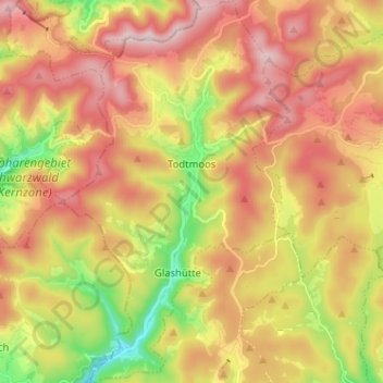
Name: Todtmoos topographic map, elevation, terrain.
Average elevation: 3,205 ft
Minimum elevation: 2,231 ft
Maximum elevation: 4,068 ft
Todtmoos ist eine Gemeinde im Landkreis Waldshut in Baden-Württemberg. Der heilklimatische Kurort liegt im Südschwarzwald auf über 700 Meter Höhe.
Other topographic maps
Click on a map to view its topography, its elevation and its terrain.
Prestenberg
Deutschland > Baden-Württemberg > Landkreis Waldshut > Todtmoos
Prestenberg, Todtmoos, Verwaltungsverband St. Blasien, Landkreis Waldshut, Baden-Württemberg, 79682, Deutschland
Average elevation: 3,419 ft