
Semeru topographic map
Interactive map
Click on the map to display elevation.
About this map
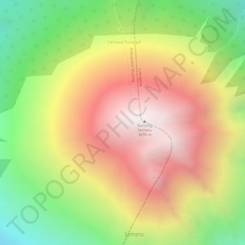
Name: Semeru topographic map, elevation, terrain.
Location: Semeru, Malang, East Java, Indonesia (-8.10805 112.91995 -8.10795 112.92005)
Average elevation: 10,161 ft
Minimum elevation: 8,005 ft
Maximum elevation: 12,008 ft
Other topographic maps
Click on a map to view its topography, its elevation and its terrain.
Gunung Prau
Indonesia > East Java > Malang
Gunung Prau, Malang, East Java, Indonesia
Average elevation: 1,158 ft
Gunung Arjuna
Indonesia > East Java > Malang
Gunung Arjuna, Malang, East Java, Indonesia
Average elevation: 5,177 ft