
Stewart Island topographic map
Interactive map
Click on the map to display elevation.
About this map
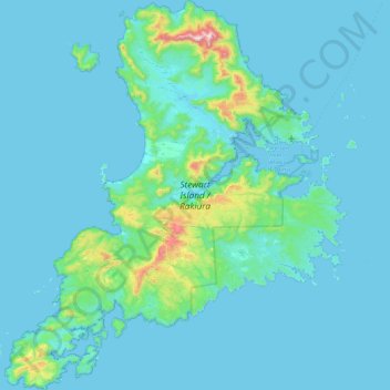
Name: Stewart Island topographic map, elevation, terrain.
Location: Stewart Island, Southland, New Zealand (-47.29000 167.44721 -46.68343 168.22927)
Average elevation: 207 ft
Minimum elevation: -7 ft
Maximum elevation: 3,173 ft
Although the clay soil is not very fertile, the high rainfall and warm weather mean that the island is densely forested throughout. Native plants include the world's southernmost dense forest of podocarps (southern conifers) and hardwoods such as rātā and kāmahi in the lowland areas with mānuka shrubland at higher elevations. The trees are thought to have become established here since the last ice age from seeds brought across the strait by seabirds, which would explain why the beech trees that are so common in New Zealand, but whose seeds are dispersed by the wind rather than birds, are not found on Stewart Island.
Other topographic maps
Click on a map to view its topography, its elevation and its terrain.
Sutherland Falls
New Zealand > Southland > Southland District > Fiordland Community
Sutherland Falls, Fiordland Community, Southland District, Southland, New Zealand
Average elevation: 3,301 ft
Mount Mackenzie
New Zealand > Southland > Southland District > Fiordland Community
Mount Mackenzie, Fiordland Community, Southland District, Southland, New Zealand
Average elevation: 3,839 ft
Milford Sound
New Zealand > Southland > Southland District > Fiordland Community
Milford Sound, Fiordland Community, Southland District, Southland, New Zealand
Average elevation: 2,149 ft
Oban
New Zealand > Southland > Southland District > Stewart Island / Rakiura Community
Oban, Stewart Island / Rakiura Community, Southland District, Southland, 9818, New Zealand
Average elevation: 75 ft
Turner Falls
New Zealand > Southland > Southland District > Fiordland Community
Turner Falls, Fiordland Community, Southland District, Southland, New Zealand
Average elevation: 4,380 ft
Invercargill City
Invercargill City, Southland, New Zealand
Average elevation: 36 ft
Misty River
New Zealand > Southland > Southland District > Fiordland Community
Misty River, Fiordland Community, Southland District, Southland, New Zealand
Average elevation: 1,240 ft
Bluff
New Zealand > Southland > Invercargill City
Bluff, Invercargill City, Southland, 9814, New Zealand
Average elevation: 36 ft
Manapouri
New Zealand > Southland > Southland District > Fiordland Community > Manapouri
Manapouri, Fiordland Community, Southland District, Southland, 7969, New Zealand
Average elevation: 699 ft
Southland District
Southland District, Southland, New Zealand
Average elevation: 1,040 ft
Te Anau
New Zealand > Southland > Southland District > Fiordland Community
Te Anau, Fiordland Community, Southland District, Southland, 9600, New Zealand
Average elevation: 817 ft