
Napier topographic map
Interactive map
Click on the map to display elevation.
About this map
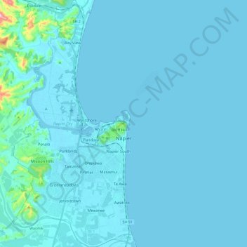
Name: Napier topographic map, elevation, terrain.
Location: Napier, Hawke's Bay, New Zealand (-39.57047 176.81127 -39.38819 176.92593)
Average elevation: 39 ft
Minimum elevation: -10 ft
Maximum elevation: 906 ft
The city is on Napier Hill and the surrounding Heretaunga Plains at the southeastern edge of Hawke Bay, a large semi-circular bay that dominates the east coast of New Zealand's North Island. The coastline of the city was substantially altered by a large earthquake in 1931. The topography puts Napier in danger from a tsunami, as the centre of the commercial city is near sea level – should the sea ever crest Marine Parade the sea would run through to Ahuriri. Furthermore, by virtue of its pre 1931 existence, the bulk of Napier is susceptible to soil liquefaction, the risk classed as Very High for the main urban area excluding the hill.
Other topographic maps
Click on a map to view its topography, its elevation and its terrain.
Cape Kidnappers / Te Kauwae-a-Māui
New Zealand > Hawke's Bay > Hastings District
Cape Kidnappers / Te Kauwae-a-Māui, Hastings District, Hawke's Bay, New Zealand
Average elevation: 52 ft
Sugarloaf
New Zealand > Hawke's Bay > Napier
Sugarloaf, Napier, Hawke's Bay, 4112, New Zealand
Average elevation: 131 ft
Hastings
New Zealand > Hawke's Bay > Hastings District
Hastings, Hastings District, Hawke's Bay, 4122, New Zealand
Average elevation: 223 ft
Central Hawke's Bay District
Central Hawke's Bay District, Hawke's Bay, New Zealand
Average elevation: 774 ft