
College Place topographic map
Interactive map
Click on the map to display elevation.
About this map
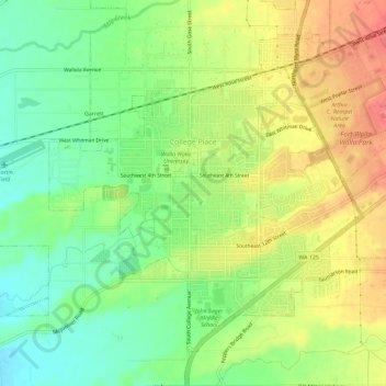
Name: College Place topographic map, elevation, terrain.
Average elevation: 801 ft
Minimum elevation: 702 ft
Maximum elevation: 906 ft
Other topographic maps
Click on a map to view its topography, its elevation and its terrain.
Walla Walla
United States > Washington > Walla Walla County
Walla Walla, Walla Walla County, Washington, 99362, United States
Average elevation: 974 ft
Ice Harbor Dam
United States > Washington > Walla Walla County
Ice Harbor Dam, Walla Walla County, Washington, United States
Average elevation: 489 ft
Burbank
United States > Washington > Walla Walla County
Burbank, Walla Walla County, Washington, 99323, United States
Average elevation: 377 ft
Waitsburg
United States > Washington > Walla Walla County
Waitsburg, Walla Walla County, Washington, United States
Average elevation: 1,358 ft
Buroker
United States > Washington > Walla Walla County
Buroker, Walla Walla County, Washington, United States
Average elevation: 1,398 ft
Wallula
United States > Washington > Walla Walla County
Wallula, Walla Walla County, Washington, United States
Average elevation: 390 ft
Dixie
United States > Washington > Walla Walla County > Dixie
Dixie, Walla Walla County, Washington, 99329, United States
Average elevation: 1,762 ft
Whitman Mission National Historic Site
United States > Washington > Walla Walla County
Whitman Mission National Historic Site, Walla Walla County, Washington, United States
Average elevation: 643 ft