
Wynnewood topographic map
Interactive map
Click on the map to display elevation.
About this map
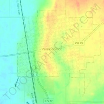
Name: Wynnewood topographic map, elevation, terrain.
Location: Wynnewood, Garvin County, Oklahoma, 73098, United States (34.63167 -97.17555 34.65353 -97.14925)
Average elevation: 889 ft
Minimum elevation: 827 ft
Maximum elevation: 951 ft
Other topographic maps
Click on a map to view its topography, its elevation and its terrain.
Paoli
United States > Oklahoma > Garvin County
Paoli, Garvin County, Oklahoma, 73074, United States
Average elevation: 948 ft
Stratford
United States > Oklahoma > Garvin County
Stratford, Garvin County, Oklahoma, 74872, United States
Average elevation: 1,115 ft
Elmore City
United States > Oklahoma > Garvin County
Elmore City, Garvin County, Oklahoma, United States
Average elevation: 991 ft
Katie
United States > Oklahoma > Garvin County
Katie, Garvin County, Oklahoma, United States
Average elevation: 955 ft
Pernell
United States > Oklahoma > Garvin County
Pernell, Garvin County, Oklahoma, United States
Average elevation: 1,007 ft
Erin Springs
United States > Oklahoma > Garvin County
Erin Springs, Garvin County, Oklahoma, United States
Average elevation: 1,004 ft
Foster
United States > Oklahoma > Garvin County
Foster, Garvin County, Oklahoma, United States
Average elevation: 1,010 ft
Wallville
United States > Oklahoma > Garvin County
Wallville, Garvin County, Oklahoma, United States
Average elevation: 1,043 ft
Hennepin
United States > Oklahoma > Garvin County
Hennepin, Garvin County, Oklahoma, 73444, United States
Average elevation: 948 ft
Purdy
United States > Oklahoma > Garvin County
Purdy, Garvin County, Oklahoma, United States
Average elevation: 1,079 ft
Maysville
United States > Oklahoma > Garvin County
Maysville, Garvin County, Oklahoma, United States
Average elevation: 958 ft
Lindsay
United States > Oklahoma > Garvin County
Lindsay, Garvin County, Oklahoma, United States
Average elevation: 984 ft
Pauls Valley
United States > Oklahoma > Garvin County
Pauls Valley, Garvin County, Oklahoma, United States
Average elevation: 902 ft