
Espírito Santo do Pinhal topographic map
Interactive map
Click on the map to display elevation.
About this map
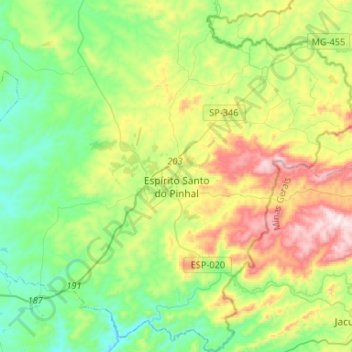
Name: Espírito Santo do Pinhal topographic map, elevation, terrain.
Average elevation: 2,779 ft
Minimum elevation: 2,001 ft
Maximum elevation: 4,393 ft
Espírito Santo do Pinhal (Portuguese meaning "Holy Spirit of Pinhal") is a municipality in the state of São Paulo in Brazil. The population in 2020 is 44,471 (IBGE 2020) and the area is 389 km². The elevation is 870 m.
Other topographic maps
Click on a map to view its topography, its elevation and its terrain.
Espírito Santo do Pinhal
Brazil > São Paulo > Espírito Santo do Pinhal
Espírito Santo do Pinhal, Região Imediata de São João da Boa Vista, Região Intermediária de Campinas, São Paulo, Southeast Region, Brazil
Average elevation: 2,644 ft