
Sete Barras topographic map
Interactive map
Click on the map to display elevation.
About this map
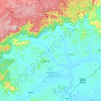
Name: Sete Barras topographic map, elevation, terrain.
Average elevation: 715 ft
Minimum elevation: 3 ft
Maximum elevation: 3,314 ft
Sete Barras is a municipality in the state of São Paulo in Brazil. The population is 12,780 (2020 est.) in an area of 1063 km². The elevation is 30 m.
Other topographic maps
Click on a map to view its topography, its elevation and its terrain.
Sete Barras
Brazil > São Paulo > Sete Barras
Sete Barras, Região Imediata de Registro, Região Intermediária de Sorocaba, São Paulo, Southeast Region, 11910-000, Brazil
Average elevation: 755 ft