
Tasikmalaya topographic map
Interactive map
Click on the map to display elevation.
About this map
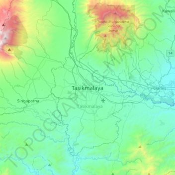
Name: Tasikmalaya topographic map, elevation, terrain.
Location: Tasikmalaya, West Java, 46151, Indonesia (-7.48625 108.06012 -7.16625 108.38012)
Average elevation: 1,709 ft
Minimum elevation: 387 ft
Maximum elevation: 7,169 ft
The city is located in the mountainous Preanger region of Java at an elevation of 351 metres (1,151 feet).
Other topographic maps
Click on a map to view its topography, its elevation and its terrain.
Mangkubumi
Indonesia > West Java > Tasikmalaya
Mangkubumi, Tasikmalaya, West Java, Java, 46181, Indonesia
Average elevation: 1,214 ft