
Gemeinde Loretto topographic map
Interactive map
Click on the map to display elevation.
About this map
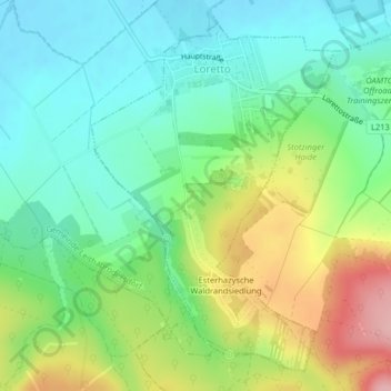
Name: Gemeinde Loretto topographic map, elevation, terrain.
Average elevation: 830 ft
Minimum elevation: 653 ft
Maximum elevation: 1,168 ft
Other topographic maps
Click on a map to view its topography, its elevation and its terrain.
Gemeinde Breitenbrunn
Austria > Burgenland > Bezirk Eisenstadt-Umgebung
Gemeinde Breitenbrunn, Bezirk Eisenstadt-Umgebung, Burgenland, 7091, Austria
Average elevation: 577 ft
Mörbisch am See
Austria > Burgenland > Bezirk Eisenstadt-Umgebung
Mörbisch am See, Bezirk Eisenstadt-Umgebung, Burgenland, 7072, Austria
Average elevation: 489 ft