
Rocigalgo topographic map
Interactive map
Click on the map to display elevation.
About this map
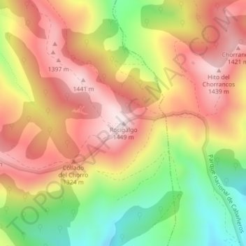
Name: Rocigalgo topographic map, elevation, terrain.
Average elevation: 3,990 ft
Minimum elevation: 3,031 ft
Maximum elevation: 4,754 ft
Other topographic maps
Click on a map to view its topography, its elevation and its terrain.
Robledo del Buey
España > Castilla-La Mancha > Los Navalucillos
Robledo del Buey, Los Navalucillos, La Jara, Toledo, Castilla-La Mancha, 45138, España
Average elevation: 2,904 ft