
Altamont topographic map
Interactive map
Click on the map to display elevation.
About this map
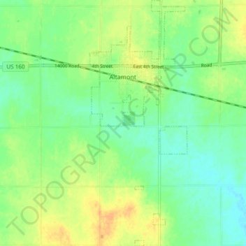
Name: Altamont topographic map, elevation, terrain.
Location: Altamont, Labette County, Kansas, 67330, United States (37.14937 -95.30726 37.20889 -95.27762)
Average elevation: 906 ft
Minimum elevation: 860 ft
Maximum elevation: 961 ft
Other topographic maps
Click on a map to view its topography, its elevation and its terrain.
Parsons
United States > Kansas > Labette County > Parsons > Parsons
Parsons, Labette County, Kansas, 67357, United States
Average elevation: 902 ft
Oswego
United States > Kansas > Labette County
Oswego, Labette County, Kansas, 67356, United States
Average elevation: 883 ft