
Yulchung topographic map
Interactive map
Click on the map to display elevation.
About this map
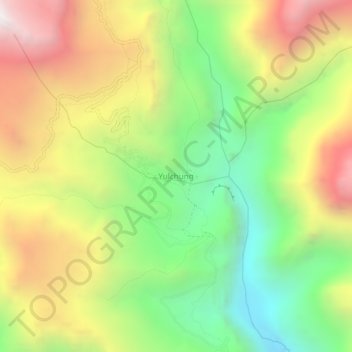
Name: Yulchung topographic map, elevation, terrain.
Location: Yulchung, Khalsi tehsil, Leh district, Ladakh, India (33.90699 76.89055 33.94699 76.93055)
Average elevation: 13,858 ft
Minimum elevation: 11,388 ft
Maximum elevation: 16,824 ft
Other topographic maps
Click on a map to view its topography, its elevation and its terrain.
Ursi
India > Ladakh > Khalsi tehsil
Ursi, Khalsi tehsil, Leh District, Ladakh, India
Average elevation: 12,930 ft
Lingshed
India > Ladakh > Khalsi tehsil
Lingshed, Khalsi tehsil, Leh District, Ladakh, India
Average elevation: 13,809 ft
Debring
India > Ladakh > Khalsi tehsil
Debring, Khalsi tehsil, Leh District, Ladakh, India
Average elevation: 14,370 ft
Lamayuru
India > Ladakh > Khalsi tehsil
Lamayuru, Khalsi tehsil, Leh district, Ladakh, India
Average elevation: 12,110 ft