
Fairmont topographic map
Interactive map
Click on the map to display elevation.
About this map
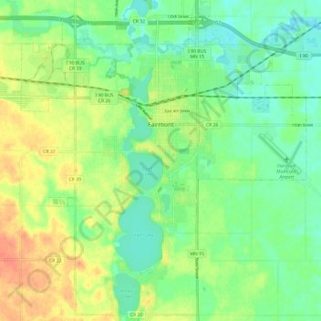
Name: Fairmont topographic map, elevation, terrain.
Location: Fairmont, Martin County, Minnesota, 56031, United States (43.59977 -94.51249 43.68514 -94.40753)
Average elevation: 1,184 ft
Minimum elevation: 1,129 ft
Maximum elevation: 1,263 ft
Other topographic maps
Click on a map to view its topography, its elevation and its terrain.
Dunnell
United States > Minnesota > Martin County
Dunnell, Martin County, Minnesota, United States
Average elevation: 1,322 ft
Sherburn
United States > Minnesota > Martin County
Sherburn, Martin County, Minnesota, United States
Average elevation: 1,289 ft