
Silver City topographic map
Interactive map
Click on the map to display elevation.
About this map
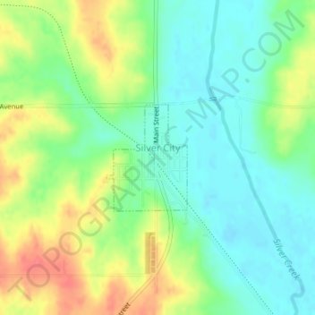
Name: Silver City topographic map, elevation, terrain.
Location: Silver City, Mills County, Iowa, United States (41.10786 -95.64310 41.11706 -95.63390)
Average elevation: 1,093 ft
Minimum elevation: 1,017 ft
Maximum elevation: 1,214 ft
Other topographic maps
Click on a map to view its topography, its elevation and its terrain.
Malvern
United States > Iowa > Mills County
Malvern, Mills County, Iowa, United States
Average elevation: 1,040 ft
Silver City
United States > Iowa > Mills County > Silver City > Silver City
Silver City, Mills County, Iowa, 51571, United States
Average elevation: 1,115 ft
Emerson
United States > Iowa > Mills County
Emerson, Mills County, Iowa, United States
Average elevation: 1,093 ft