
Talbot County topographic map
Interactive map
Click on the map to display elevation.
About this map
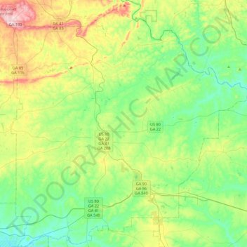
Name: Talbot County topographic map, elevation, terrain.
Location: Talbot County, Georgia, United States (32.51848 -84.70320 32.88360 -84.28625)
Average elevation: 633 ft
Minimum elevation: 328 ft
Maximum elevation: 1,345 ft
The county straddles the fall line of the Eastern U.S., and thus northern areas of the county are hillier compared to southern areas of the county. The Fall Line Freeway runs across the southern portion of the county, following Georgia State Route 96 from Geneva to Junction City. The far northern portion of the county is part of the Pine Mountain Range, with elevations in this areas exceeding 1,000 ft on the highest peaks of the mountains.
Other topographic maps
Click on a map to view its topography, its elevation and its terrain.
Atlanta
United States > Georgia > Fulton County
Atlanta, Fulton County, Georgia, United States
Average elevation: 932 ft
Athens
United States > Georgia > Athens
Athens, Athens-Clarke County, Georgia, 303341458, United States
Average elevation: 725 ft
Blue Ridge
United States > Georgia > Fannin County
Blue Ridge, Fannin County, Georgia, United States
Average elevation: 1,755 ft
Savannah
United States > Georgia > Chatham County
Savannah, Chatham County, Georgia, United States
Average elevation: 13 ft
Helen
United States > Georgia > White County
Helen, White County, Georgia, 30545, United States
Average elevation: 1,601 ft
Ellijay
United States > Georgia > Gilmer County
Ellijay, Gilmer County, Georgia, 30540, United States
Average elevation: 1,391 ft
Tybee Island
United States > Georgia > Chatham County
Tybee Island, Chatham County, Georgia, 31328, United States
Average elevation: 3 ft
Gwinnett County
Gwinnett County, Georgia, United States
Average elevation: 991 ft
Saint Simons Island
United States > Georgia > Glynn County
Saint Simons Island, Glynn County, Georgia, 31561, United States
Average elevation: 7 ft
Augusta
United States > Georgia > Augusta
Augusta, Richmond County, Georgia, 30901, United States
Average elevation: 295 ft
Macon
United States > Georgia > Bibb County
Macon, Bibb County, Georgia, United States
Average elevation: 417 ft
Atlanta
United States > Georgia > Fulton County
Atlanta, Fulton County, Georgia, 30303, United States
Average elevation: 935 ft
Blairsville
United States > Georgia > Union County
Blairsville, Union County, Georgia, United States
Average elevation: 1,926 ft
Dahlonega
United States > Georgia > Lumpkin County
Dahlonega, Lumpkin County, Georgia, United States
Average elevation: 1,348 ft
Columbus
United States > Georgia > Muscogee County
Columbus, Muscogee County, Georgia, United States
Average elevation: 427 ft
Carroll County
Carroll County, Georgia, United States
Average elevation: 1,066 ft
Hiawassee
United States > Georgia > Towns County
Hiawassee, Towns County, Georgia, United States
Average elevation: 2,034 ft
Alpharetta
United States > Georgia > Fulton County
Alpharetta, Fulton County, Georgia, United States
Average elevation: 1,063 ft
Skidaway Island
United States > Georgia > Chatham County
Skidaway Island, Chatham County, Georgia, 31411, United States
Average elevation: 10 ft
Brunswick
United States > Georgia > Glynn County
Brunswick, Glynn County, Georgia, United States
Average elevation: 7 ft
Fannin County
Fannin County, Georgia, United States
Average elevation: 2,060 ft
Lumpkin
United States > Georgia > Stewart County
Lumpkin, Stewart County, Georgia, United States
Average elevation: 482 ft
Gainesville
United States > Georgia > Hall County
Gainesville, Hall County, Georgia, 30501, United States
Average elevation: 1,135 ft
Canton
United States > Georgia > Cherokee County
Canton, Cherokee County, Georgia, United States
Average elevation: 1,050 ft
Vinings
United States > Georgia > Cobb County
Vinings, Cobb County, Georgia, 30339, United States
Average elevation: 922 ft
Jointer Island
United States > Georgia > Glynn County > Brunswick
Jointer Island, Brunswick, Glynn County, Georgia, United States
Average elevation: 0 ft
Heritage Acres
United States > Georgia > Bibb County > Macon
Heritage Acres, Macon, Bibb County, Georgia, 31211, United States
Average elevation: 390 ft
Robins Air Force Base
United States > Georgia > Houston County
Robins Air Force Base, Houston County, Georgia, 31098, United States
Average elevation: 302 ft
Stone Mountain
United States > Georgia > DeKalb County
Stone Mountain, DeKalb County, Georgia, 30087, United States
Average elevation: 981 ft
Woodstock
United States > Georgia > Cherokee County
Woodstock, Cherokee County, Georgia, United States
Average elevation: 971 ft
Mountain City
United States > Georgia > Rabun County
Mountain City, Rabun County, Georgia, 30562, United States
Average elevation: 2,451 ft
Forsyth County
Forsyth County, Georgia, United States
Average elevation: 1,129 ft
Lake Oconee
United States > Georgia > Greene County > Lake Oconee
Lake Oconee, Greene County, Georgia, United States
Average elevation: 541 ft
Kennesaw
United States > Georgia > Cobb County
Kennesaw, Cobb County, Georgia, 30144, United States
Average elevation: 1,040 ft
Iron Mountain
United States > Georgia > Murray County
Iron Mountain, Murray County, Georgia, United States
Average elevation: 1,188 ft
Fort Pulaski
United States > Georgia > Chatham County
Fort Pulaski, Fort Perimeter Trail, Chatham County, Georgia, 31328, United States
Average elevation: 3 ft
Tugaloo
United States > Georgia > Habersham County > Tallulah Falls
Tugaloo, Tallulah Falls, Habersham County, Georgia, United States
Average elevation: 1,286 ft
Elmodel
United States > Georgia > Baker County
Elmodel, Baker County, Georgia, United States
Average elevation: 167 ft
Leary
United States > Georgia > Calhoun County
Leary, Calhoun County, Georgia, 39862, United States
Average elevation: 200 ft
Fargo
United States > Georgia > Clinch County
Fargo, Clinch County, Georgia, United States
Average elevation: 112 ft
Worley Crossroads
United States > Georgia > Cherokee County
Worley Crossroads, Cherokee County, Georgia, United States
Average elevation: 1,240 ft
Fernwood
United States > Georgia > Fayette County > Peachtree City
Fernwood, Peachtree City, Fayette County, Georgia, 30269, United States
Average elevation: 856 ft
Valdosta
United States > Georgia > Lowndes County
Valdosta, Lowndes County, Georgia, United States
Average elevation: 190 ft