
Águilas topographic map
Interactive map
Click on the map to display elevation.
About this map
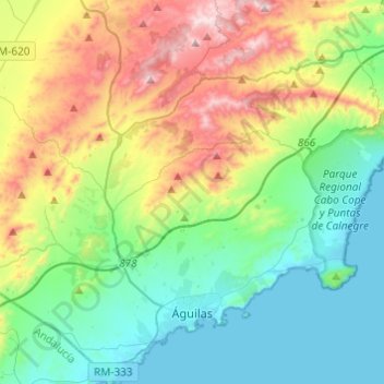
Name: Águilas topographic map, elevation, terrain.
Location: Águilas, Alto Guadalentín, Region of Murcia, Spain (37.37377 -1.70502 37.56659 -1.46772)
Average elevation: 856 ft
Minimum elevation: -3 ft
Maximum elevation: 2,785 ft
Other topographic maps
Click on a map to view its topography, its elevation and its terrain.
Lorca
Spain > Region of Murcia > Alto Guadalentín
Lorca, Alto Guadalentín, Region of Murcia, Spain
Average elevation: 1,762 ft