
Nominingue topographic map
Interactive map
Click on the map to display elevation.
About this map
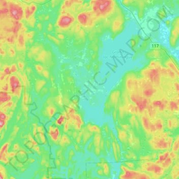
Name: Nominingue topographic map, elevation, terrain.
Average elevation: 1,001 ft
Minimum elevation: 771 ft
Maximum elevation: 1,588 ft
Other topographic maps
Click on a map to view its topography, its elevation and its terrain.
Saint-Aimé-du-Lac-des-Îles
Canada > Quebec > Antoine-Labelle > Saint-Aimé-du-Lac-des-Îles
Saint-Aimé-du-Lac-des-Îles, Antoine-Labelle, Laurentides, Quebec, Canada
Average elevation: 843 ft