
Retuerta del Bullaque topographic map
Interactive map
Click on the map to display elevation.
About this map
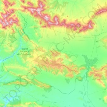
Name: Retuerta del Bullaque topographic map, elevation, terrain.
Average elevation: 2,605 ft
Minimum elevation: 1,677 ft
Maximum elevation: 4,741 ft
Other topographic maps
Click on a map to view its topography, its elevation and its terrain.
El embalse de Torre de Abraham
España > Castilla-La Mancha > Retuerta del Bullaque > Retuerta del Bullaque
El embalse de Torre de Abraham, CM-403, Pueblo Nuevo de Bullaque, Retuerta del Bullaque, Montes, Ciudad Real, Castilla-La Mancha, España
Average elevation: 2,287 ft