
Bardy topographic map
Interactive map
Click on the map to display elevation.
About this map
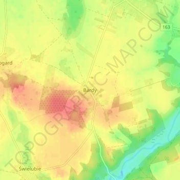
Name: Bardy topographic map, elevation, terrain.
Average elevation: 105 ft
Minimum elevation: -10 ft
Maximum elevation: 184 ft
Other topographic maps
Click on a map to view its topography, its elevation and its terrain.
Kołobrzeg
Poland > West Pomeranian Voivodeship > Colberg County
Kołobrzeg, Colberg County, West Pomeranian Voivodeship, 78-100, Poland
Average elevation: 16 ft
Siemyśl
Poland > West Pomeranian Voivodeship > Colberg County
Siemyśl, gmina Siemyśl, Colberg County, West Pomeranian Voivodeship, 78-123, Poland
Average elevation: 112 ft
Charzyno
Poland > West Pomeranian Voivodeship > Colberg County
Charzyno, gmina Siemyśl, Colberg County, West Pomeranian Voivodeship, 78-122, Poland
Average elevation: 92 ft
Kołobrzeg
Poland > West Pomeranian Voivodeship > Colberg County > Kołobrzeg
Kołobrzeg, Colberg County, West Pomeranian Voivodeship, 78-100, Poland
Average elevation: 16 ft