
Cazo topographic map
Interactive map
Click on the map to display elevation.
About this map
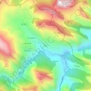
Name: Cazo topographic map, elevation, terrain.
Location: Cazo, Ponga, Asturias, España (43.24228 -5.23161 43.28228 -5.19161)
Average elevation: 1,939 ft
Minimum elevation: 725 ft
Maximum elevation: 3,655 ft
Other topographic maps
Click on a map to view its topography, its elevation and its terrain.
Parque Natural de Ponga
Parque Natural de Ponga, Carretera Beleño - Los Beyos, Ponga, Asturias, 33558, España
Average elevation: 3,340 ft
Piedrafita
Piedrafita, Ponga, Asturias, 24996, España
Average elevation: 4,987 ft