
Pondok Jagung topographic map
Interactive map
Click on the map to display elevation.
About this map
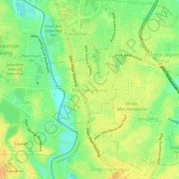
Name: Pondok Jagung topographic map, elevation, terrain.
Location: Pondok Jagung, South Tangerang, Banten, 15326, Indonesia (-6.27957 106.63478 -6.23957 106.67478)
Average elevation: 92 ft
Minimum elevation: 33 ft
Maximum elevation: 141 ft
Other topographic maps
Click on a map to view its topography, its elevation and its terrain.
Sutera Feronia
Indonesia > Banten > South Tangerang > Pondok Jagung
Sutera Feronia, Jalan Sutera Feronia 4, Alam Sutera, Pondok Jagung, South Tangerang, Banten, 15326, Indonesia
Average elevation: 95 ft