
Keswick topographic map
Interactive map
Click on the map to display elevation.
About this map
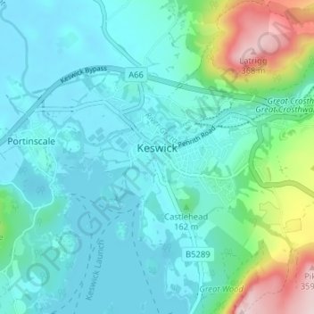
Name: Keswick topographic map, elevation, terrain.
Location: Keswick, Allerdale, Cumbria, England, United Kingdom (54.58732 -3.16352 54.61249 -3.09942)
Average elevation: 420 ft
Minimum elevation: 233 ft
Maximum elevation: 1,211 ft
Other topographic maps
Click on a map to view its topography, its elevation and its terrain.
Barf
United Kingdom > England > Cumbria > Allerdale
Barf, Allerdale, Cumbria, England, CA12 5SJ, United Kingdom
Average elevation: 869 ft
Aspatria
United Kingdom > England > Cumbria > Allerdale
Aspatria, Allerdale, Cumbria, North West England, England, United Kingdom
Average elevation: 180 ft
Pike
United Kingdom > England > Cumbria > Allerdale
Pike, Allerdale, Cumbria, North West England, England, CA12 4TE, United Kingdom
Average elevation: 748 ft