
Xinyi City topographic map
Interactive map
Click on the map to display elevation.
About this map
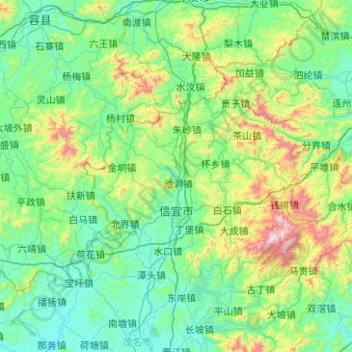
Name: Xinyi City topographic map, elevation, terrain.
Location: Xinyi City, Maoming City, Guangdong, 525300, China (22.19075 110.67927 22.70726 111.68284)
Average elevation: 1,001 ft
Minimum elevation: 75 ft
Maximum elevation: 5,417 ft
Other topographic maps
Click on a map to view its topography, its elevation and its terrain.
Nanhu Sub-district
China > Guangdong > Shenzhen City > Nanhu Sub-district
Nanhu Sub-district, Luohu District, Shenzhen City, Guangdong, 518000, China
Average elevation: 95 ft
Xiashan District
Xiashan District, Zhanjiang City, Guangdong, China
Average elevation: 72 ft