
Treherbert topographic map
Interactive map
Click on the map to display elevation.
About this map
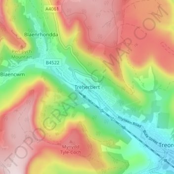
Name: Treherbert topographic map, elevation, terrain.
Location: Treherbert, Rhondda Cynon Taf, Wales, CF42 5PT, United Kingdom (51.65437 -3.55513 51.69437 -3.51513)
Average elevation: 1,132 ft
Minimum elevation: 522 ft
Maximum elevation: 1,785 ft
Other topographic maps
Click on a map to view its topography, its elevation and its terrain.
Clydach Vale
United Kingdom > Wales > Rhondda Cynon Taf
Clydach Vale, Rhondda Cynon Taf, Wales, CF40 2EG, United Kingdom
Average elevation: 902 ft
Virgin Falls
United Kingdom > Wales > Rhondda Cynon Taf > Blaencwm
Virgin Falls, Blaencwm, Rhondda Cynon Taf, Wales, CF42 5EA, United Kingdom
Average elevation: 1,316 ft
Trebanog
United Kingdom > Wales > Rhondda Cynon Taf
Trebanog, Rhondda Cynon Taf, Wales, CF39 9EW, United Kingdom
Average elevation: 689 ft
Llantwit Fardre
United Kingdom > Wales > Rhondda Cynon Taf
Llantwit Fardre, Rhondda Cynon Taf, Wales, CF38 2EN, United Kingdom
Average elevation: 404 ft
Pontypridd
United Kingdom > Wales > Rhondda Cynon Taf
Pontypridd, Rhondda Cynon Taf, Wales, United Kingdom
Average elevation: 600 ft