
District 2 topographic map
Interactive map
Click on the map to display elevation.
About this map
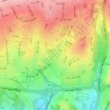
Name: District 2 topographic map, elevation, terrain.
Average elevation: 4,780 ft
Minimum elevation: 4,508 ft
Maximum elevation: 5,020 ft
Other topographic maps
Click on a map to view its topography, its elevation and its terrain.
Shemiranat County
Iran > Tehran Province > Tajrish City
Tajrish City, بخش رودبار قصران, Shemiranat County, Iran
Average elevation: 5,568 ft