
Jinan City topographic map
Interactive map
Click on the map to display elevation.
About this map
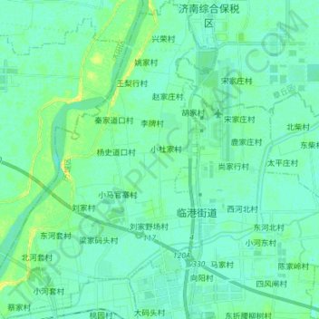
Name: Jinan City topographic map, elevation, terrain.
Location: 遥墙街道, Licheng District, Jinan City, Shandong, 250100, China (36.78508 117.10931 36.89716 117.21016)
Average elevation: 79 ft
Minimum elevation: 62 ft
Maximum elevation: 118 ft
Other topographic maps
Click on a map to view its topography, its elevation and its terrain.
The Border
China > Shandong > Jinan City > The Border
The Border, Jinan City, Changqing District, Shandong, 250300, China
Average elevation: 755 ft
Jinan City
China > Shandong > Jinan City
临港街道, Licheng District, Jinan City, Shandong, 250100, China
Average elevation: 79 ft