
La Romana topographic map
Interactive map
Click on the map to display elevation.
About this map
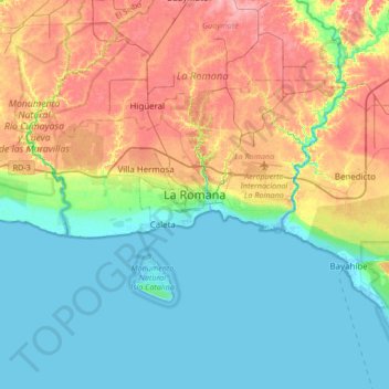
Name: La Romana topographic map, elevation, terrain.
Location: La Romana, 2200, Dominican Republic (18.26728 -69.13346 18.58728 -68.81346)
Average elevation: 118 ft
Minimum elevation: -16 ft
Maximum elevation: 338 ft
Other topographic maps
Click on a map to view its topography, its elevation and its terrain.
Catalina Island
Dominican Republic > La Romana > La Romana > Caleta
Catalina Island, Caleta, La Romana, Dominican Republic
Average elevation: 7 ft