
Kunohe topographic map
Interactive map
Click on the map to display elevation.
About this map
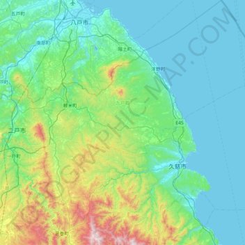
Name: Kunohe topographic map, elevation, terrain.
Location: Kunohe, Iwate Prefecture, Tohoku, Japan (40.01275 141.35010 40.56034 142.03118)
Average elevation: 686 ft
Minimum elevation: 0 ft
Maximum elevation: 4,026 ft
Other topographic maps
Click on a map to view its topography, its elevation and its terrain.
Lake Towada
Lake Towada, Towada Prince Hotel, Kosaka, Kazuno, Akita Prefecture, Tohoku, 0185501, Japan
Average elevation: 1,608 ft
Mt. Gassan
Mt. Gassan, Tsuruoka, Yamagata Prefecture, Tohoku, Japan
Average elevation: 5,479 ft