
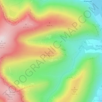
The Tongue topographic map
Interactive map
Click on the map to display elevation.
About this map
Name: The Tongue topographic map, elevation, terrain.
Average elevation: 1,447 ft
Minimum elevation: 715 ft
Maximum elevation: 2,300 ft
Other topographic maps
Click on a map to view its topography, its elevation and its terrain.
Glenridding Dodd
United Kingdom > England > Eden
Glenridding Dodd, Eden, Cumbria, North West England, England, CA11 0QH, United Kingdom
Average elevation: 961 ft
Eden
United Kingdom > England > Eden
Eden, Cumbria, North West England, England, United Kingdom
Average elevation: 1,043 ft
Souther Fell
United Kingdom > England > Eden
Souther Fell, Eden, Cumbria, North West England, England, CA11 0XR, United Kingdom
Average elevation: 1,145 ft
Cross Fell
United Kingdom > England > Eden
Cross Fell, Eden, Cumbria, North West England, England, United Kingdom
Average elevation: 2,470 ft