Geolocate

Tibesti topographic map

Interactive map

Click on the map to display elevation.

About this map

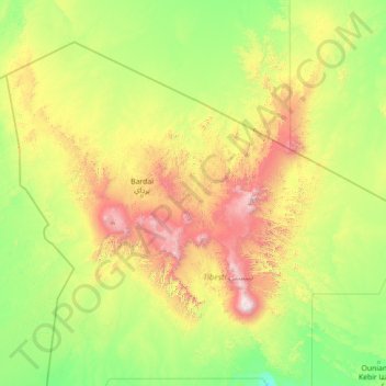
Name: Tibesti topographic map, elevation, terrain.

Location: Tibesti, Chad (18.71887 15.78600 24.01419 20.17188)

Average elevation: 2,628 ft

Minimum elevation: 1,010 ft

Maximum elevation: 11,001 ft

Tibesti, which means "place where the mountain people live", is the domain of the Toubou people. The Toubou live mainly along the wadis, on rare oases where palm trees and limited grains grow. They harness the water that collects in gueltas, the supply of which is highly variable from year-to-year and decade-to-decade. The plateaus are used to graze livestock in the winter and harvest grain in the summer. Temperatures are high, although the altitude ensures that the range is cooler than the surrounding desert. The Toubou, who were settled in the range by the 5th century BC, adapted to these conditions and turned the range into a large natural fortress. They arrived in several waves, taking refuge in times of conflict and dispersing in times of prosperity, although not without intense internal hostility at times.

Wikipedia (CC-BY-SA 3.0)

Other topographic maps

Click on a map to view its topography, its elevation and its terrain.

Bigué

Chad > Chari-Baguirmi

Bigué, Chari-Baguirmi, Chad

Average elevation: 1,109 ft

Am Chéchia

Chad > Hadjer-Lamis

Am Chéchia, Hadjer-Lamis, Chad

Average elevation: 945 ft

Mya

Chad > Moyen-Chari

Mya, Moyen-Chari, Chad

Average elevation: 1,198 ft

Babo

Chad > Mandoul

Babo, Mandoul, Chad

Average elevation: 1,237 ft

Kilkila

Chad > Sila

Kilkila, Sila, Chad

Average elevation: 1,716 ft

Kirirom

Chad > Artoumassi 3

Kirirom, Artoumassi 3, Chad

Average elevation: 951 ft

Kamanga 2

Chad > Moyen-Chari

Kamanga 2, Moyen-Chari, Chad

Average elevation: 1,204 ft

Tibesti Mountains

Chad

Tibesti Mountains, Chad

Average elevation: 3,133 ft

Mandah

Chad > Logone Oriental

Mandah, Logone Oriental, Chad

Average elevation: 1,572 ft

Matarka Botoua

Chad > Kanem

Matarka Botoua, Kanem, Chad

Average elevation: 968 ft

N'Djamena

Chad

N'Djamena, Chad

Average elevation: 965 ft

Wadi Fira

Chad

Wadi Fira, Chad

Average elevation: 2,205 ft

Key

Chad > Ennedi-Ouest

Key, Ennedi-Ouest, Chad

Average elevation: 1,929 ft

Sila

Chad

Sila, Chad

Average elevation: 1,785 ft

Logone Occidental

Chad

Logone Occidental, Chad

Average elevation: 1,427 ft

East Ennedi

Chad

East Ennedi, Chad

Average elevation: 2,251 ft

Lac

Chad

Lac, Chad

Average elevation: 981 ft

Djamena

Chad > Chari-Baguirmi > Mandelia

Djamena, Mandelia, Chari-Baguirmi, Chad

Average elevation: 984 ft

Logone Oriental

Chad

Logone Oriental, Chad

Average elevation: 1,496 ft

Tandjilé

Chad

Tandjilé, Chad

Average elevation: 1,198 ft

Mayo-Kebbi Est

Chad

Mayo-Kebbi Est, Chad

Average elevation: 1,119 ft

Moyen-Chari

Chad

Moyen-Chari, Chad

Average elevation: 1,283 ft

Ouaddaï

Chad

Ouaddaï, Chad

Average elevation: 2,152 ft

Salamat

Chad

Salamat, Chad

Average elevation: 1,476 ft

Chari-Baguirmi

Chad

Chari-Baguirmi, Chad

Average elevation: 1,063 ft

Bahr el Gazel

Chad

Bahr el Gazel, Chad

Average elevation: 978 ft

Batha

Chad

Batha, Chad

Average elevation: 1,207 ft

Guéra

Chad

Guéra, Chad

Average elevation: 1,306 ft

Kanem

Chad

Kanem, Chad

Average elevation: 1,010 ft

Kousseri

Chad > Mandoul

Kousseri, Mandoul, Chad

Average elevation: 1,178 ft

Mandoul

Chad

Mandoul, Chad

Average elevation: 1,302 ft

Samarie

Chad > Moyen-Chari

Samarie, Moyen-Chari, Chad

Average elevation: 1,243 ft

Kabia

Chad > Mayo-Kebbi Est > Gounou Gaya

Kabia, Gounou Gaya, Mayo-Kebbi Est, Chad

Average elevation: 1,145 ft

Mondo

Chad > Kanem > Mondo

Mondo, Kanem, Chad

Average elevation: 981 ft

Hadjer-Lamis

Chad

Hadjer-Lamis, Chad

Average elevation: 1,010 ft

Lake Chad

Chad > Hadjer-Lamis

Lake Chad, Hadjer-Lamis, Chad

Average elevation: 925 ft

Mayan

Chad > Mandoul > Mayan

Mayan, Mandoul, Chad

Average elevation: 1,207 ft

Karoub

Chad > Sila > Karoub

Karoub, Sila, Chad

Average elevation: 1,991 ft

Hadjer Dara

Chad > Wadi Fira

Hadjer Dara, Wadi Fira, Chad

Average elevation: 2,264 ft

Bendje

Chad > Mandoul

Bendje, Mandoul, Chad

Average elevation: 1,214 ft

Kousseri

Chad > Moyen-Chari > Kousseri

Kousseri, Moyen-Chari, Chad

Average elevation: 1,250 ft

Farcha

Chad > Mandoul > Farcha

Farcha, Mandoul, Chad

Average elevation: 1,201 ft

Batha De Laïri

Chad > Moyen-Chari

Batha De Laïri, Moyen-Chari, Chad

Average elevation: 1,181 ft

Hiam

Chad > Moyen-Chari > Hiam

Hiam, Moyen-Chari, Chad

Average elevation: 1,286 ft

Kabia

Chad > Mayo-Kebbi Est

Kabia, Mayo-Kebbi Est, Chad

Average elevation: 1,112 ft

Prah

Chad > Moyen-Chari > Prah

Prah, Moyen-Chari, Chad

Average elevation: 1,165 ft

Kousseri

Chad > Batha > Kousseri

Kousseri, Batha, Chad

Average elevation: 1,175 ft

Tibesti

Chad > Tibesti

Tibesti, Chad

Average elevation: 2,178 ft

Iro بحيرة إيرو

Chad > Moyen-Chari > Campement Pêcheur Borno

Iro بحيرة إيرو, Campement Pêcheur Borno, Moyen-Chari, Chad

Average elevation: 1,273 ft

Batha

Chad > Batha > Umm Hajar

Batha, Umm Hajar, Batha, Chad

Average elevation: 1,319 ft