
Robinsville topographic map
Interactive map
Click on the map to display elevation.
About this map
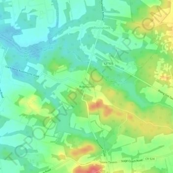
Name: Robinsville topographic map, elevation, terrain.
Average elevation: 184 ft
Minimum elevation: 102 ft
Maximum elevation: 338 ft
Other topographic maps
Click on a map to view its topography, its elevation and its terrain.
Stone Tavern
United States > New Jersey > Monmouth County > Upper Freehold Township
Stone Tavern, Upper Freehold Township, Monmouth County, New Jersey, 08555, United States
Average elevation: 203 ft
Ellisdale
United States > New Jersey > Monmouth County > Upper Freehold Township
Ellisdale, Upper Freehold Township, Monmouth County, New Jersey, United States
Average elevation: 112 ft