
福建省 topographic map
Interactive map
Click on the map to display elevation.
About this map
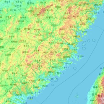
Name: 福建省 topographic map, elevation, terrain.
Location: 福建省, 中国 (23.19948 115.84731 28.32052 121.03366)
Average elevation: 978 ft
Minimum elevation: -7 ft
Maximum elevation: 7,051 ft
福建位于中国东南部,土地总面积为12.40万平方公里,占全国的1.3%,居全国第23位。地势西北高,东南低,全省土地总面积的90%是山地丘陵,所谓“八山一水一分田”。省内有闽西与闽中两大山带大体平行,闽西山带以武夷山脉为主,斜貫闽、赣两省,长约530千米,平均海拔1千米。最高峰黄岗山海拔2158米,位于武夷山市西北部,是中国东南地区最高峰。闽中山带从北至南分为鹫峰山脉、戴云山脉、博平岭。
Other topographic maps
Click on a map to view its topography, its elevation and its terrain.