
Kappil topographic map
Interactive map
Click on the map to display elevation.
About this map
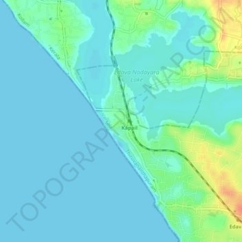
Name: Kappil topographic map, elevation, terrain.
Average elevation: 30 ft
Minimum elevation: -3 ft
Maximum elevation: 144 ft
Other topographic maps
Click on a map to view its topography, its elevation and its terrain.
Edava Nadayara Lake
Edava Nadayara Lake, Cliff 1st street, Kappil, Chirayinkeezhu, Thiruvananthapuram, Kerala, 695311, India
Average elevation: 39 ft