
Monteverde topographic map
Interactive map
Click on the map to display elevation.
About this map
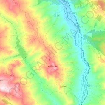
Name: Monteverde topographic map, elevation, terrain.
Location: Monteverde, Avellino, Campania, Italy (40.96605 15.49351 41.05404 15.57231)
Average elevation: 1,539 ft
Minimum elevation: 738 ft
Maximum elevation: 2,713 ft
Other topographic maps
Click on a map to view its topography, its elevation and its terrain.
Quaglietta
Italy > Campania > Avellino > Calabritto
Quaglietta, Calabritto, Avellino, Campania, Italy
Average elevation: 1,050 ft