
Village of Morrisville topographic map
Interactive map
Click on the map to display elevation.
About this map
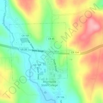
Name: Village of Morrisville topographic map, elevation, terrain.
Average elevation: 1,434 ft
Minimum elevation: 1,240 ft
Maximum elevation: 1,706 ft
Other topographic maps
Click on a map to view its topography, its elevation and its terrain.
Cazenovia Lake
United States > New York > Madison County > Town of Cazenovia
Cazenovia Lake, Town of Cazenovia, Madison County, New York, United States
Average elevation: 1,224 ft
Leonardsville
United States > New York > Madison County > Town of Brookfield
Leonardsville, Town of Brookfield, Madison County, New York, 13364, United States
Average elevation: 1,345 ft
Charles E. Baker State Forest
United States > New York > Madison County > Town of Brookfield
Charles E. Baker State Forest, Town of Brookfield, Madison County, New York, United States
Average elevation: 1,581 ft
Village of Wampsville
United States > New York > Madison County
Village of Wampsville, Town of Lenox, Madison County, New York, 13163, United States
Average elevation: 492 ft
Town of Brookfield
United States > New York > Madison County
Town of Brookfield, Madison County, New York, United States
Average elevation: 1,516 ft
Town of DeRuyter
United States > New York > Madison County
Town of DeRuyter, Madison County, New York, 13052, United States
Average elevation: 1,568 ft
Sheds
United States > New York > Madison County
Sheds, Town of DeRuyter, Madison County, New York, 13122, United States
Average elevation: 1,591 ft
Bridgeport
United States > New York > Madison County
Bridgeport, Town of Sullivan, Madison County, New York, 13030, United States
Average elevation: 387 ft
Town of Cazenovia
United States > New York > Madison County
Town of Cazenovia, Madison County, New York, United States
Average elevation: 1,362 ft
North Brookfield
United States > New York > Madison County > Town of Brookfield
North Brookfield, Town of Brookfield, Madison County, New York, 13418, United States
Average elevation: 1,450 ft
Poolville
United States > New York > Madison County > Town of Hamilton
Poolville, Town of Hamilton, Madison County, New York, United States
Average elevation: 1,280 ft
Lenox
United States > New York > Madison County
Lenox, Madison County, New York, 13032, United States
Average elevation: 640 ft
Town of Nelson
United States > New York > Madison County
Town of Nelson, Madison County, New York, 13061, United States
Average elevation: 1,611 ft
Village of Canastota
United States > New York > Madison County
Village of Canastota, Town of Lenox, Madison County, New York, 13032, United States
Average elevation: 436 ft
Georgetown
United States > New York > Madison County > Georgetown
Georgetown, Town of Georgetown, Madison County, New York, 13072, United States
Average elevation: 1,670 ft
Peterboro
United States > New York > Madison County > Peterboro
Peterboro, Town of Smithfield, Madison County, New York, 13134, United States
Average elevation: 1,325 ft
Village of Cazenovia
United States > New York > Madison County
Village of Cazenovia, Town of Cazenovia, Madison County, New York, 13035, United States
Average elevation: 1,240 ft
Village of Hamilton
United States > New York > Madison County > Town of Hamilton
Village of Hamilton, Town of Hamilton, Madison County, New York, 13346, United States
Average elevation: 1,266 ft
Village of Earlville
United States > New York > Madison County > Town of Hamilton
Village of Earlville, Town of Hamilton, Madison County, New York, United States
Average elevation: 1,122 ft
City of Oneida
United States > New York > Madison County
City of Oneida, Madison County, New York, 13421, United States
Average elevation: 541 ft