
Yasuj topographic map
Interactive map
Click on the map to display elevation.
About this map
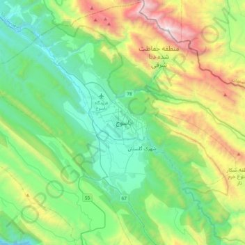
Name: Yasuj topographic map, elevation, terrain.
Average elevation: 7,661 ft
Minimum elevation: 5,262 ft
Maximum elevation: 13,957 ft
Other topographic maps
Click on a map to view its topography, its elevation and its terrain.
Boyer Ahmad
Iran > Kohgiluye and Buyer Ahmad Province > Buyerahmad County > Yasuj
Boyer Ahmad, ناحیه ۱, Yasuj, بخش مرکزی بویراحمد, Buyerahmad County, Kohgiluye and Buyer Ahmad Province, Iran
Average elevation: 6,053 ft