
Redwater topographic map
Interactive map
Click on the map to display elevation.
About this map
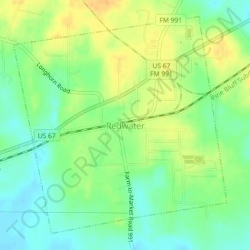
Name: Redwater topographic map, elevation, terrain.
Location: Redwater, Bowie County, Texas, 75573, United States (33.34651 -94.26885 33.36996 -94.24122)
Average elevation: 285 ft
Minimum elevation: 236 ft
Maximum elevation: 341 ft
Other topographic maps
Click on a map to view its topography, its elevation and its terrain.
Nash
United States > Texas > Bowie County
Nash, Bowie County, Texas, 75569, United States
Average elevation: 341 ft
College Hill
United States > Texas > Bowie County
College Hill, Bowie County, Texas, United States
Average elevation: 348 ft
Texarkana
United States > Texas > Bowie County
Texarkana, Bowie County, Texas, United States
Average elevation: 325 ft
Hooks
United States > Texas > Bowie County > Hooks > Hooks
Hooks, Bowie County, Texas, 75561, United States
Average elevation: 374 ft
New Boston
United States > Texas > Bowie County
New Boston, Bowie County, Texas, 75570, United States
Average elevation: 354 ft
De Kalb
United States > Texas > Bowie County
De Kalb, Bowie County, Texas, 75559, United States
Average elevation: 387 ft