
Carleton Place topographic map
Interactive map
Click on the map to display elevation.
About this map
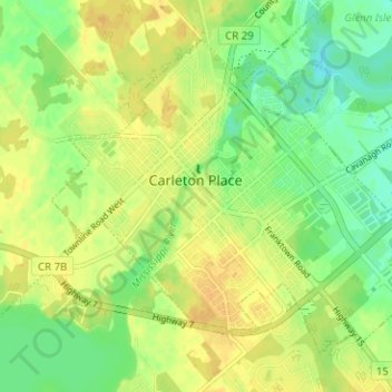
Name: Carleton Place topographic map, elevation, terrain.
Average elevation: 449 ft
Minimum elevation: 400 ft
Maximum elevation: 486 ft
Other topographic maps
Click on a map to view its topography, its elevation and its terrain.
Mississippi River
Canada > Ontario > Lanark County > Drummond-North Elmsley > Innisville > Ferguson Falls
Mississippi River, Ferguson Falls, Innisville, Drummond-North Elmsley, Lanark County, Eastern Ontario, Ontario, Canada
Average elevation: 486 ft
Flower Station
Canada > Ontario > Lanark County > Lanark Highlands > Flower Station
Flower Station, Lanark Highlands, Lanark County, Eastern Ontario, Ontario, Canada
Average elevation: 768 ft