
Blue Nile topographic map
Interactive map
Click on the map to display elevation.
About this map
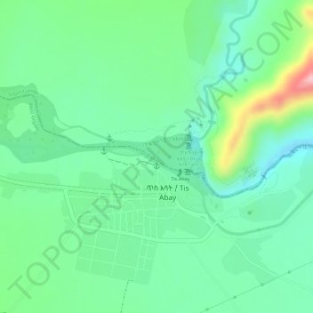
Name: Blue Nile topographic map, elevation, terrain.
Location: Blue Nile, South Gonder, Amhara Region, Ethiopia (11.48813 37.58253 11.49020 37.58613)
Average elevation: 5,404 ft
Minimum elevation: 5,220 ft
Maximum elevation: 5,801 ft
Although there are several feeder streams that flow into Lake Tana, the sacred source of the river is generally considered to be a small spring at Gish Abay, situated at an elevation of approximately 2,744 metres (9,003 ft). This stream, known as the Gilgel Abay (Lesser Abay River), flows north into Lake Tana. Other affluents of this lake include, in clockwise order from Gorgora, the Magech River, the Northern Gumara, the Reb River, the southern Gumara River, and the Kilte. Lake Tana's outflow then flows some 30 kilometres (19 mi) before plunging over the Blue Nile Falls. The river then loops across northwest Ethiopia through a series of deep valleys and canyons into Sudan, by which point it is only known as the Blue Nile.
Other topographic maps
Click on a map to view its topography, its elevation and its terrain.
Dalota
Dalota, North Shewa (Amhara Region), Amhara Region, Ethiopia
Average elevation: 6,115 ft
Ambassador Park
Ethiopia > Addis Ababa > Arada > Addis Ababa
Ambassador Park, Posta Bet, Addis Ababa, Arada, Addis Ababa, Ethiopia
Average elevation: 7,795 ft
Durum
Ethiopia > Southern Nations, Nationalities, and Peoples
Durum, South Omo, Southern Nations, Nationalities, and Peoples, Ethiopia
Average elevation: 1,421 ft
Gorki
Gorki, South West Shewa, Oromia Region, Ethiopia
Average elevation: 7,110 ft
Wayu
Ethiopia > Oromia Region > Jimma Rare
Wayu, Jimma Rare, Horo Guduru, Oromia Region, Ethiopia
Average elevation: 7,602 ft
Dimtu
Ethiopia > Benishangul-Gumuz Region
Dimtu, Kemashi, Benishangul-Gumuz Region, Ethiopia
Average elevation: 3,606 ft
Danakil Depression
Danakil Depression, Zone 2, Afar Region, Ethiopia
Average elevation: -377 ft
Waliso
Waliso, South West Shewa, Oromia Region, Ethiopia
Average elevation: 6,706 ft
Mille
Ethiopia > Afar Region > Lower Miele
Mille, Lower Miele, Zone 1, Afar Region, Ethiopia
Average elevation: 1,627 ft
Addis Ababa
Ethiopia > Addis Ababa > Arada
Addis Ababa, Arada, Addis Ababa, 3578, Ethiopia
Average elevation: 8,258 ft
Welkite
Ethiopia > Southern Nations, Nationalities, and Peoples
Welkite, Guraghe, Southern Nations, Nationalities, and Peoples, Ethiopia
Average elevation: 5,928 ft
Chinaksen
Chinaksen, East Harerghe, Oromia Region, Ethiopia
Average elevation: 6,670 ft
Jimma Rare
Jimma Rare, Horo Guduru, Oromia Region, Ethiopia
Average elevation: 7,664 ft
Melka Awash
Melka Awash, South West Shewa, Oromia Region, Ethiopia
Average elevation: 6,742 ft
Woldia
Woldia, North Wollo Zone, Amhara Region, Ethiopia
Average elevation: 6,608 ft
Burk'A Shet'
Burk'A Shet', East Harerghe, Oromia Region, Ethiopia
Average elevation: 3,497 ft
Lake Hawassa
Lake Hawassa, Hawassa, West Arsi, Sidama, Ethiopia
Average elevation: 5,594 ft
Emdibir
Ethiopia > Southern Nations, Nationalities, and Peoples
Emdibir, Guraghe, Southern Nations, Nationalities, and Peoples, Ethiopia
Average elevation: 6,837 ft
Adama
Ethiopia > Oromia Region > Adama
Adama, Adama Special Zone, Oromia Region, 36, Ethiopia
Average elevation: 5,489 ft
Sheger Park - Phase 2
Ethiopia > Addis Ababa > Arada
Sheger Park - Phase 2, Eri Bekentu, Arat Kilo, Arada, Addis Ababa, Ethiopia
Average elevation: 7,917 ft