
Almont topographic map
Interactive map
Click on the map to display elevation.
About this map
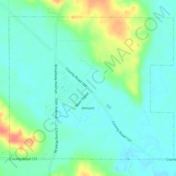
Name: Almont topographic map, elevation, terrain.
Location: Almont, Morton County, North Dakota, United States (46.71739 -101.52035 46.73933 -101.48347)
Average elevation: 1,942 ft
Minimum elevation: 1,893 ft
Maximum elevation: 2,073 ft
Other topographic maps
Click on a map to view its topography, its elevation and its terrain.
Mandan
United States > North Dakota > Morton County
Mandan, Morton County, North Dakota, 58554, United States
Average elevation: 1,749 ft
Flasher
United States > North Dakota > Morton County > Flasher
Flasher, Morton County, North Dakota, 58535, United States
Average elevation: 1,952 ft