
Seymour topographic map
Interactive map
Click on the map to display elevation.
About this map
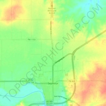
Name: Seymour topographic map, elevation, terrain.
Location: Seymour, Baylor County, Texas, 76380, United States (33.57758 -99.28730 33.65528 -99.23953)
Average elevation: 1,316 ft
Minimum elevation: 1,243 ft
Maximum elevation: 1,398 ft
The climate is humid subtropical (Köppen: Cfa) with an extreme temperature deviation, but much of the time, the variation is always more and the warm weather prevails over the cold as the averages and the records show. Its subtropical location and south of the center of a large land mass bring occasional outbreaks even to a latitude and not very high altitude. The climate in this area is characterized by hot, humid summers and generally mild to cool winters, sometimes cold. On August 12, 1936, Seymour witnessed the record highest temperature in Texas (120 °F) (49 °C), a record that was tied by the city of Monahans on June 28, 1994.
Other topographic maps
Click on a map to view its topography, its elevation and its terrain.
Lake Kemp
United States > Texas > Baylor County
Lake Kemp, Baylor County, Texas, United States
Average elevation: 1,181 ft
Red Springs
United States > Texas > Baylor County
Red Springs, Baylor County, Texas, United States
Average elevation: 1,371 ft
Bomarton
United States > Texas > Baylor County
Bomarton, Baylor County, Texas, United States
Average elevation: 1,407 ft
Westover
United States > Texas > Baylor County
Westover, Baylor County, Texas, United States
Average elevation: 1,289 ft
Mabelle
United States > Texas > Baylor County
Mabelle, Baylor County, Texas, United States
Average elevation: 1,296 ft
Seymour
United States > Texas > Baylor County
Seymour, Baylor County, Texas, 76380, United States
Average elevation: 1,316 ft