
Clarcona topographic map
Interactive map
Click on the map to display elevation.
About this map
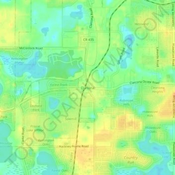
Name: Clarcona topographic map, elevation, terrain.
Average elevation: 102 ft
Minimum elevation: 49 ft
Maximum elevation: 151 ft
Other topographic maps
Click on a map to view its topography, its elevation and its terrain.
Lake Eva
United States > Florida > Orange County > Apopka > Plymouth
Lake Eva, Plymouth, Apopka, Orange County, Florida, United States
Average elevation: 98 ft
Wekiwa Springs State Park
United States > Florida > Orange County > Apopka
Wekiwa Springs State Park, Apopka, Orange County, Florida, United States
Average elevation: 62 ft
Bay Ridge
United States > Florida > Orange County > Apopka
Bay Ridge, Apopka, Orange County, Florida, 32798, United States
Average elevation: 118 ft