
Mont-Saint-Pierre topographic map
Interactive map
Click on the map to display elevation.
About this map
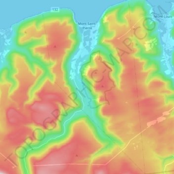
Name: Mont-Saint-Pierre topographic map, elevation, terrain.
Average elevation: 1,096 ft
Minimum elevation: -10 ft
Maximum elevation: 2,543 ft
Other topographic maps
Click on a map to view its topography, its elevation and its terrain.
Mont-Albert
Canada > Quebec > La Haute-Gaspésie
Mont-Albert, La Haute-Gaspésie, Gaspésie–Îles-de-la-Madeleine, Quebec, G4V 2E4, Canada
Average elevation: 1,401 ft
Gaspésie
Canada > Quebec > La Haute-Gaspésie > Mont-Albert
Gaspésie, Mont-Albert, La Haute-Gaspésie, Gaspésie–Îles-de-la-Madeleine, Quebec, Canada
Average elevation: 1,506 ft
Sainte-Anne-des-Monts
Canada > Quebec > La Haute-Gaspésie
Sainte-Anne-des-Monts, La Haute-Gaspésie, Gaspésie–Îles-de-la-Madeleine, Quebec, Canada
Average elevation: 571 ft