
Kendari topographic map
Interactive map
Click on the map to display elevation.
About this map
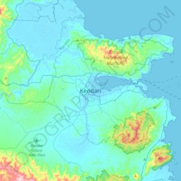
Name: Kendari topographic map, elevation, terrain.
Location: Kendari, Southeast Sulawesi, Sulawesi, Indonesia (-4.15181 122.35801 -3.83181 122.67801)
Average elevation: 210 ft
Minimum elevation: -10 ft
Maximum elevation: 1,998 ft
Kendari borders the Konawe Regency in the north, South Konawe Regency in the south and west, and Kendari Bay in the east. The city is on the southeastern part of mainland Sulawesi island; several smaller islands around the bay are within its boundaries. The city's topography varies from flat to hilly. Coastal areas tend to be flatter, while the northern part of the city is part of the Nipa-Nipa mountain formation, which reaches elevations of approximately 450 metres (1,480 ft). In general, the city's slopes are less than 25 percent except for those in the north, which in some places exceed 40 percent.
Other topographic maps
Click on a map to view its topography, its elevation and its terrain.
Konawe
Indonesia > Southeast Sulawesi
Konawe, Southeast Sulawesi, Sulawesi, Indonesia
Average elevation: 1,407 ft
Wakatobi
Indonesia > Southeast Sulawesi
Wakatobi, Southeast Sulawesi, Sulawesi, Indonesia
Average elevation: 13 ft
Wakatobi National Park
Indonesia > Southeast Sulawesi
Wakatobi National Park, Southeast Sulawesi, Sulawesi, Indonesia
Average elevation: 3 ft
Desa Tampabulu
Indonesia > Southeast Sulawesi
Desa Tampabulu, Southeast Sulawesi, 93773, Indonesia
Average elevation: 118 ft
Baruta
Indonesia > Southeast Sulawesi > Baruta
Baruta, Southeast Sulawesi, Indonesia
Average elevation: 157 ft
Pulau Manui
Indonesia > Southeast Sulawesi
Pulau Manui, Southeast Sulawesi, Indonesia
Average elevation: 3 ft
Konawe
Indonesia > Southeast Sulawesi > Konawe
Konawe, Southeast Sulawesi, Indonesia
Average elevation: 98 ft
Kendari
Indonesia > Southeast Sulawesi
Kendari, Southeast Sulawesi, 93121, Indonesia
Average elevation: 220 ft
Baubau
Indonesia > Southeast Sulawesi > Baubau
Baubau, Southeast Sulawesi, 97326, Indonesia
Average elevation: 387 ft