
Amherst topographic map
Interactive map
Click on the map to display elevation.
About this map
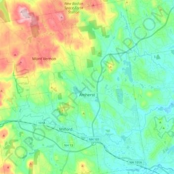
Name: Amherst topographic map, elevation, terrain.
Average elevation: 417 ft
Minimum elevation: 164 ft
Maximum elevation: 1,050 ft
According to the United States Census Bureau, the town has a total area of 34.4 square miles (89.1 km2), of which 33.9 square miles (87.8 km2) are land and 0.50 square miles (1.3 km2), or 1.49% of the total area, are water. The entire town is part of the Merrimack River watershed. The Souhegan River, an east-flowing tributary of the Merrimack, passes through the southern part of the town, and the Souhegan's tributary Beaver Brook drains the central part of town and passes through the main village. Baboosic Lake is farther north, along the eastern border of the town and is fed by Joe English Brook. The lake drains to the east into Baboosic Brook, a tributary of the Merrimack. Pulpit Brook, which drains the northeast corner of the town, flows into Baboosic Brook as well. Witches Brook flows through the southernmost part of the town and is a tributary of Pennichuck Brook, yet another tributary of the Merrimack. Amherst's highest point is on Chestnut Hill at the town's northern border, where the elevation reaches 865 feet (264 m) above sea level.
Other topographic maps
Click on a map to view its topography, its elevation and its terrain.
Manchester
United States > New Hampshire > Hillsborough County
Manchester, Hillsborough County, New Hampshire, United States
Average elevation: 315 ft
Nashua
United States > New Hampshire > Hillsborough County
Nashua, Hillsborough County, New Hampshire, United States
Average elevation: 203 ft
Lyndeborough
United States > New Hampshire > Hillsborough County
Lyndeborough, Hillsborough County, New Hampshire, 03082, United States
Average elevation: 804 ft
West Peterborough
United States > New Hampshire > Hillsborough County > Peterborough
West Peterborough, Peterborough, Hillsborough County, New Hampshire, 03468, United States
Average elevation: 981 ft
East Merrimack
United States > New Hampshire > Hillsborough County > Merrimack
East Merrimack, Merrimack, Hillsborough County, New Hampshire, 03054, United States
Average elevation: 180 ft
Pinardville
United States > New Hampshire > Hillsborough County > Goffstown
Pinardville, Goffstown, Hillsborough County, New Hampshire, 03102, United States
Average elevation: 282 ft
Grasmere
United States > New Hampshire > Hillsborough County > Goffstown
Grasmere, Goffstown, Hillsborough County, New Hampshire, 03045, United States
Average elevation: 377 ft
Reeds Ferry
United States > New Hampshire > Hillsborough County > Merrimack
Reeds Ferry, Merrimack, Hillsborough County, New Hampshire, 03054, United States
Average elevation: 190 ft
Bedford
United States > New Hampshire > Hillsborough County
Bedford, Hillsborough County, New Hampshire, 03110, United States
Average elevation: 318 ft
Horace Lake
United States > New Hampshire > Hillsborough County > Weare
Horace Lake, Weare, Hillsborough County, New Hampshire, United States
Average elevation: 804 ft
New Ipswich
United States > New Hampshire > Hillsborough County
New Ipswich, Hillsborough County, New Hampshire, 03071, United States
Average elevation: 1,112 ft
New Boston
United States > New Hampshire > Hillsborough County
New Boston, Hillsborough County, New Hampshire, 03070, United States
Average elevation: 630 ft
Pelham
United States > New Hampshire > Hillsborough County
Pelham, Hillsborough County, New Hampshire, 03076, United States
Average elevation: 226 ft
Goffstown
United States > New Hampshire > Hillsborough County
Goffstown, Hillsborough County, New Hampshire, 03045, United States
Average elevation: 522 ft
Weare
United States > New Hampshire > Hillsborough County
Weare, Hillsborough County, New Hampshire, United States
Average elevation: 689 ft
Peterborough
United States > New Hampshire > Hillsborough County
Peterborough, Hillsborough County, New Hampshire, United States
Average elevation: 997 ft
Sharon
United States > New Hampshire > Hillsborough County
Sharon, Hillsborough County, New Hampshire, United States
Average elevation: 1,247 ft
Merrimack River
United States > New Hampshire > Hillsborough County > Nashua
Merrimack River, Ward 3, Nashua, Hillsborough County, New Hampshire, United States
Average elevation: 253 ft
Brookline
United States > New Hampshire > Hillsborough County
Brookline, Hillsborough County, New Hampshire, 03033, United States
Average elevation: 413 ft
Antrim
United States > New Hampshire > Hillsborough County
Antrim, Hillsborough County, New Hampshire, 03440, United States
Average elevation: 948 ft
Shipley Hill
United States > New Hampshire > Hillsborough County > Nashua
Shipley Hill, Nashua, Hillsborough County, New Hampshire, 03039, United States
Average elevation: 253 ft
Joe English Hill
United States > New Hampshire > Hillsborough County > New Boston
Joe English Hill, New Boston, Hillsborough County, New Hampshire, 03070, United States
Average elevation: 810 ft
Hudson
United States > New Hampshire > Hillsborough County
Hudson, Hillsborough County, New Hampshire, 03051, United States
Average elevation: 223 ft
Hollis
United States > New Hampshire > Hillsborough County
Hollis, Hillsborough County, New Hampshire, United States
Average elevation: 331 ft
Gibson Four Corners
United States > New Hampshire > Hillsborough County > New Ipswich
Gibson Four Corners, New Ipswich, Hillsborough County, New Hampshire, 03071, United States
Average elevation: 1,076 ft
Riverdale
United States > New Hampshire > Hillsborough County > New Boston
Riverdale, New Boston, Hillsborough County, New Hampshire, United States
Average elevation: 430 ft
Litchfield
United States > New Hampshire > Hillsborough County
Litchfield, Hillsborough County, New Hampshire, 03052, United States
Average elevation: 220 ft
Greenville
United States > New Hampshire > Hillsborough County
Greenville, Hillsborough County, New Hampshire, United States
Average elevation: 945 ft
Hancock
United States > New Hampshire > Hillsborough County
Hancock, Hillsborough County, New Hampshire, 03449, United States
Average elevation: 984 ft
Nashua
United States > New Hampshire > Hillsborough County > Nashua
Nashua, Hillsborough County, New Hampshire, 03060-03064, United States
Average elevation: 269 ft
Mason
United States > New Hampshire > Hillsborough County
Mason, Hillsborough County, New Hampshire, 03048, United States
Average elevation: 751 ft
Mountain Base
United States > New Hampshire > Hillsborough County > Goffstown
Mountain Base, Goffstown, Hillsborough County, New Hampshire, 03045, United States
Average elevation: 679 ft
Cricket Corner
United States > New Hampshire > Hillsborough County > Amherst
Cricket Corner, Amherst, Hillsborough County, New Hampshire, 03031, United States
Average elevation: 256 ft
Massabesic Lake
United States > New Hampshire > Hillsborough County > Manchester
Massabesic Lake, Manchester, Hillsborough County, New Hampshire, United States
Average elevation: 295 ft
Deering
United States > New Hampshire > Hillsborough County
Deering, Hillsborough County, New Hampshire, United States
Average elevation: 899 ft
Temple
United States > New Hampshire > Hillsborough County
Temple, Hillsborough County, New Hampshire, 03084, United States
Average elevation: 1,135 ft
Mont Vernon
United States > New Hampshire > Hillsborough County
Mont Vernon, Hillsborough County, New Hampshire, 03057, United States
Average elevation: 640 ft
Hillsborough
United States > New Hampshire > Hillsborough County
Hillsborough, Hillsborough County, New Hampshire, 03244, United States
Average elevation: 978 ft
Manchester
United States > New Hampshire > Hillsborough County > Manchester
Manchester, Hillsborough County, New Hampshire, 03108, United States
Average elevation: 413 ft
Wilton
United States > New Hampshire > Hillsborough County
Wilton, Hillsborough County, New Hampshire, 03086, United States
Average elevation: 584 ft
Bennington
United States > New Hampshire > Hillsborough County
Bennington, Hillsborough County, New Hampshire, 03442, United States
Average elevation: 853 ft
Merrimack
United States > New Hampshire > Hillsborough County
Merrimack, Hillsborough County, New Hampshire, 03054, United States
Average elevation: 223 ft
Hillsborough
United States > New Hampshire > Hillsborough County
Hillsborough, Hillsborough County, New Hampshire, 03244, United States
Average elevation: 830 ft
Francestown
United States > New Hampshire > Hillsborough County
Francestown, Hillsborough County, New Hampshire, United States
Average elevation: 906 ft
Windsor
United States > New Hampshire > Hillsborough County
Windsor, Hillsborough County, New Hampshire, United States
Average elevation: 1,230 ft
Milford
United States > New Hampshire > Hillsborough County
Milford, Hillsborough County, New Hampshire, 03055, United States
Average elevation: 374 ft
Greenfield
United States > New Hampshire > Hillsborough County
Greenfield, Hillsborough County, New Hampshire, 03047, United States
Average elevation: 945 ft
MacDowell Colony
United States > New Hampshire > Hillsborough County > Peterborough
MacDowell Colony, Peterborough, Hillsborough County, New Hampshire, 03458, United States
Average elevation: 856 ft