
Söderhamn topographic map
Interactive map
Click on the map to display elevation.
About this map
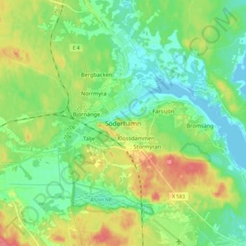
Name: Söderhamn topographic map, elevation, terrain.
Location: Söderhamn, Söderhamns kommun, Gävleborg County, 826 30, Sweden (61.25985 17.02076 61.33985 17.10076)
Average elevation: 79 ft
Minimum elevation: -3 ft
Maximum elevation: 233 ft
Other topographic maps
Click on a map to view its topography, its elevation and its terrain.
Sandvikens kommun
Sandvikens kommun, Gävleborg County, Sweden
Average elevation: 354 ft
Vista
Vista, Sandvikens kommun, Gävleborg County, Sweden
Average elevation: 223 ft
Los
Los, Ljusdals kommun, Gävleborg County, 827 70, Sweden
Average elevation: 1,273 ft
Hofors kommun
Hofors kommun, Gävleborg County, Sweden
Average elevation: 482 ft
Adams
Sweden > Gävleborg County > Björkberg
Adams, Björkberg, Hamra distrikt, Ljusdals kommun, Gävleborg County, Sweden
Average elevation: 1,312 ft
Hudiksvall
Hudiksvall, Hudiksvalls kommun, Gävleborg County, 824 23, Sweden
Average elevation: 108 ft
Bollnäs kommun
Bollnäs kommun, Gävleborg County, Sweden
Average elevation: 620 ft